Lindesnes

Day 1: Vigeland-Lindesnes fyr-Svenevig (44 km)

The long trip has started. I reached Vigeland at 13:30, and instead of waiting for two hours for another bus which could have taken me closer to Lindesnes fyr lighthouse, the intended starting point of my trip, I decided to cycle there instead. This meant 27 kilometres of cycling in the wrong direction, but given the distance which lies ahead of me, this seemed neglectable. 

I reached Lindesnes fyr at 15:30 and took some compulsory pictures there. I can certainly say that German tourists are well represented here, so Norwegian or English skills wouldn’t have been necessary. The lighthouse itself is a picturesque landmark, so I stayed some time to take pictures and enjoy a cup of coffee. 

They had a book there in which all Norge på langs tourists can write a greeting. So I took some time to read the stories of my predecessors. Most people seem to travel the other way around – from north to south. So this was there endpoint. Many of them were cyclists, but many of them have also walked/skied the whole way (which is the real Norge på langs challenge, I assume). My favourite quote in the book: “This trip must be experienced. But it cannot be recommended.” (“Turen må oppleves, men anbefales ikke.”)

I was not going to cycle long today. After another 17 kilometres in the opposite, that means the right direction to the north, I found a lovely bay with a perfect spot for my tent. I’m sitting by the sea now on a bench writing my diary and will soon go into my tent. 

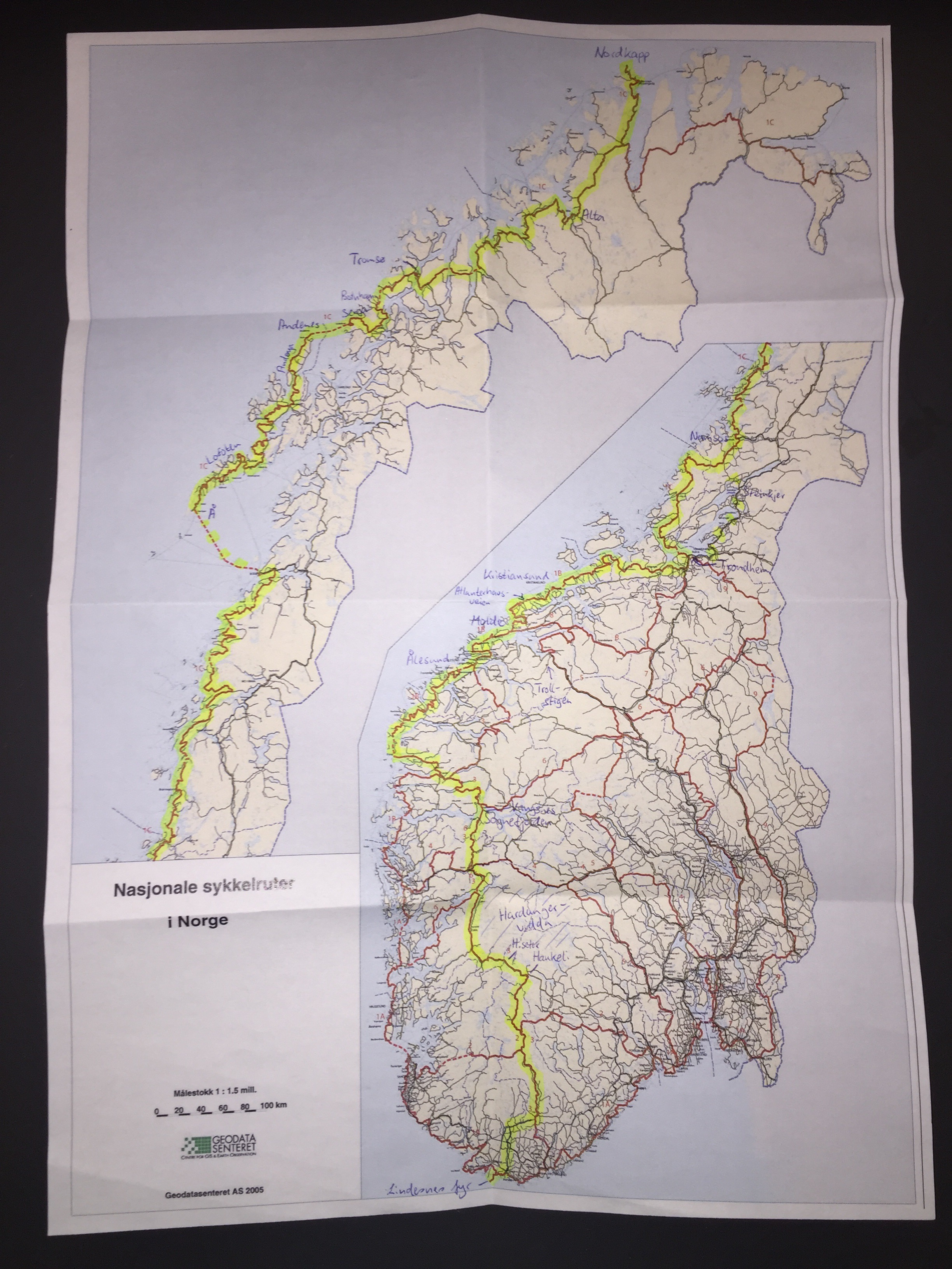
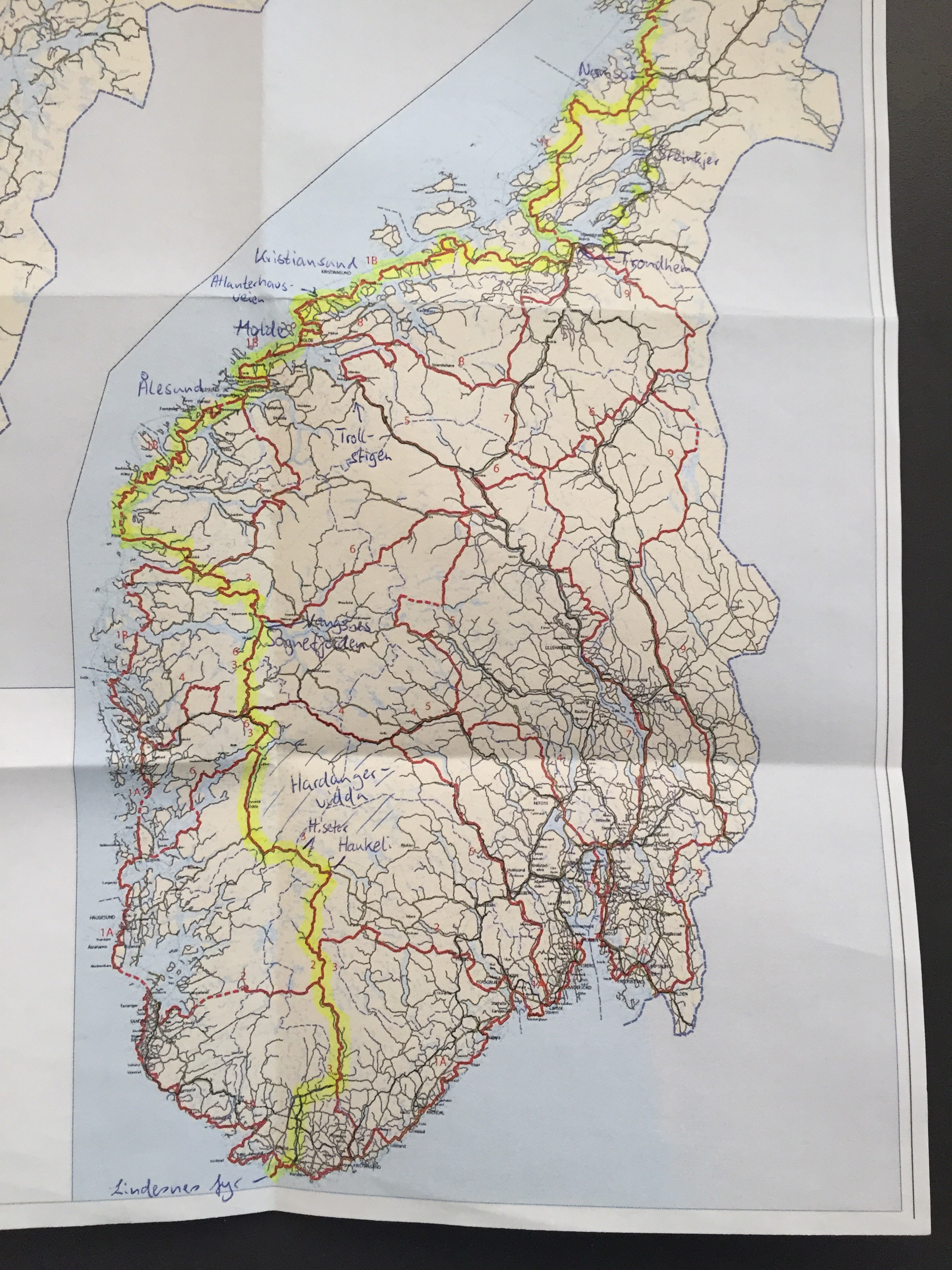
I have booked a room at Haukeliseter fjellstue, a mountain lodge, for Friday. So I have three days to go there which is a bit less than 300 kilometres from here. The weather was great today and is supposed to be fine tomorrow, too – according to yr.no and Mr. Nansen. 

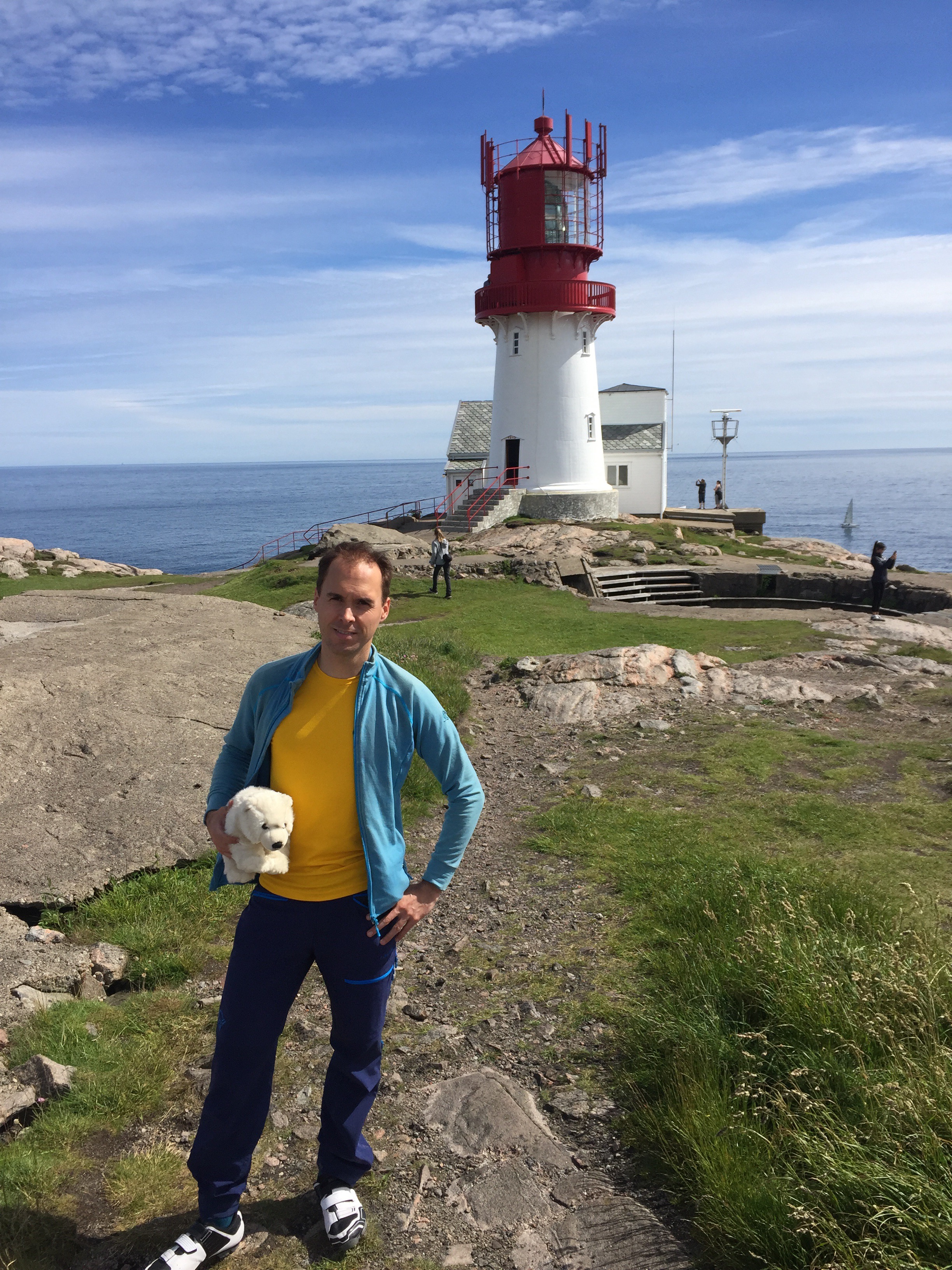
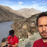
Starting point Lindesnes fyr – Norway’s southernmost point

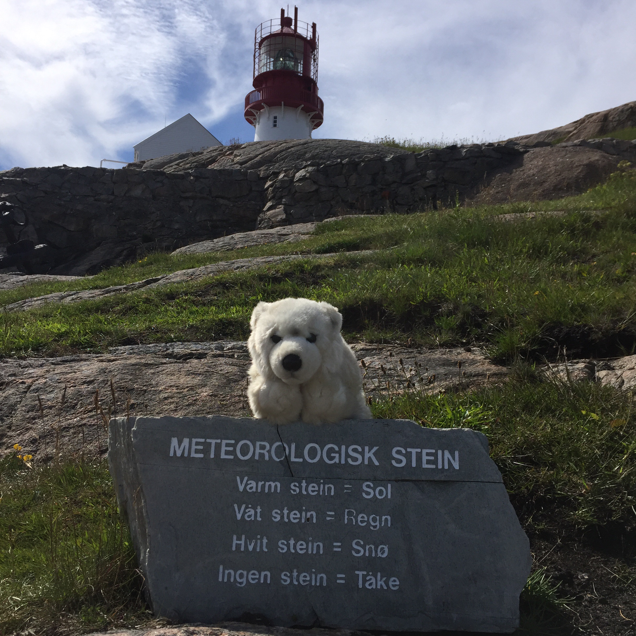
Punxsutawney Nansen predicts sunshine

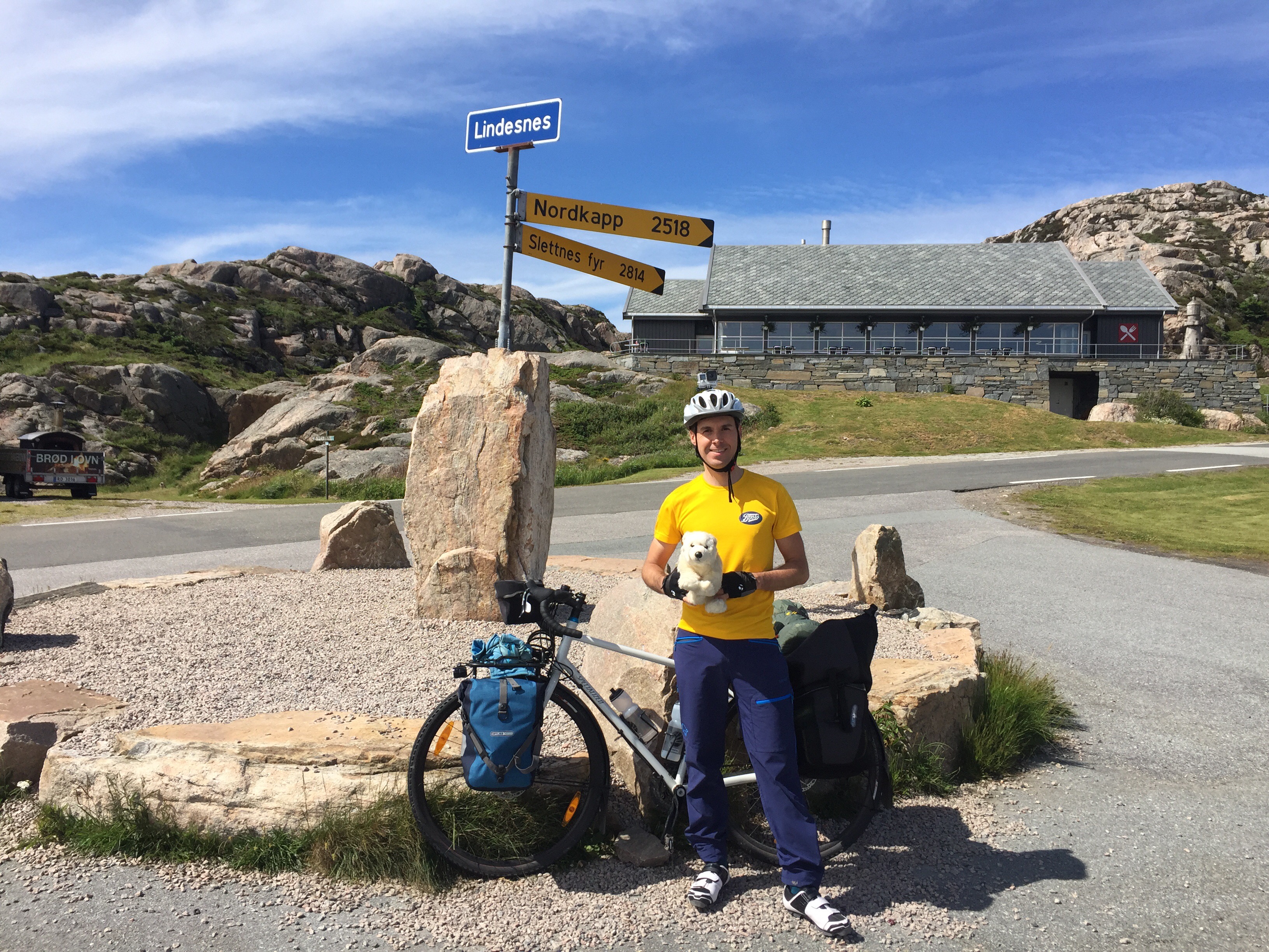
2500 km to go to Nordkapp – beeline that is

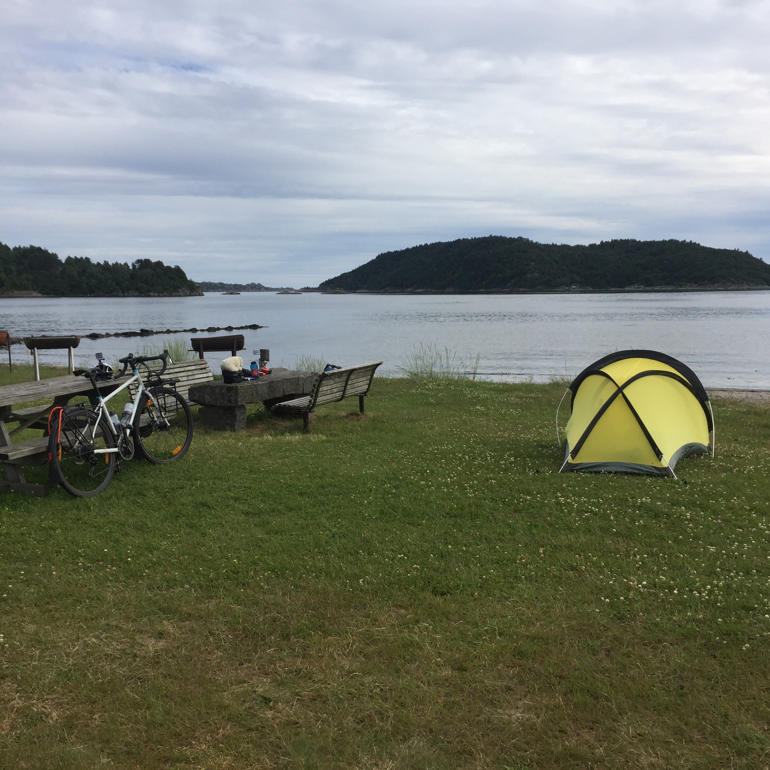
First camp spot at Svenevig

Norge på langs

For the next six weeks my plan is to cycle through Norway from the south to the north – or “Norge på langs” in Norwegian. I’m currently on the train from Oslo to Kristiansand from where I will take a bus to Lindesnes. Lindesnes fyr is a lighthouse which will be the starting point for my trip. 

From here I will cycle north, pass by the Hardangervidda plateau and cross some of the fjords of the Westland. I plan to reach the coast south of Ålesund and follow it through Molde and Kristiansund. Next stops are Trondheim, Steinkjer, Namsos and then a looong stretch along the coast again to Bodø. From here I plan to take a ferry to the Lofoten peninsula and continue via Andøya and Senja to Tromsø. From Tromsø the final section goes via Alta to Nordkapp – which is my final destination. It’s actually not the northernmost point in Norway, but Mr. Nansen accepted this choice. 

In total I have planned six weeks for this trip of roughly 3100 to 3200 kilometres. In average, my plan is to cycle 100 kilometres per day which would allow me to take a rest day every fifth day. I will try to mostly sleep outside and brought both a tent and a hammock – which I have never slept in before, so that is going to be exciting. PDF version of the map above. 

Broad Peak expedition ends 250 metres below summit

After twelve long waiting days at base camp, we finally got our chance to make a try for Broad Peak summit. We started our summit push at 11 PM in the evening of 24th July. Together with a Spanish-led expedition we were eleven climbers with headlamps on our way to the summit. It soon became clear that this was going to be a tough task due to deep snow. Whoever went first, sank in half a metre at each step. Going first were almost all the time our guides Ryan and Tomás who did a tremendous job!

At ten o’clock in the morning – after eleven hours – we were right below a col at 7800 metres which we had hoped to reach after six hours. Here suddenly clouds appeared and the wind got stronger. Since we also had to think about the long way back down, we had to take the difficult decision to turn around – after an 11 hours long tough climb, seven weeks in Pakistan, and just 250 metres below the summit.

We are now on the hike out. I will come back with pictures once we are back in civilisation.

Still waiting at base camp

We have had a weather shift and are currently stuck at base camp for a weather window that allows us to make an attempt to reach the summit. For the last eleven days we have been waiting at base camp – only walking over to K2 base camp once which is about an hour away, and going for short walks up or down the glacier some of the other days so that we don’t get rusty. There are strong winds high on the mountain at the moment, but they are supposed to die off quite soon according to our weather report, so that we hopefully will get a shot at the summit in a few days. Ryan has written a longer dispatch about the situation on www.mtnprofessionals.com/news.

Cold and windy at camp 2

Nine days have passed since my last update here. During this time we have been up on the mountain again twice, trying to reach camp 2 at 6200 metres.
Our first attempt we started the 3rd of July at three o’clock in the morning. We knew that several other teams were going up to camp 1 the same day, so we wanted to be out early. We reached camp 1 at nine o’clock. That was one hour faster than the first time.
We enjoyed the lunch bag our cook Ali had packed for us as a second breakfast. Then we tried to sleep a bit, but the sun was directly on our tents, so it was extremely hot. It was also very crowded in camp – every single one of the few tent spots were taken.
During the afternoon it became more windy and started to snow. Unfortunately, this kind of weather continued the whole night. At 4 AM, Ryan called base camp on the radio and asked our high altitude porter Fida, who was supposed to join us, not to come up. When we woke up around six, the weather hadn’t changed, so Ryan and Tomás decided that it was safer to go down. So unfortunately we didn’t reach camp 2 as planned this time.
On Wednesday, the 6th of July, we started our second attempt at 3:30 AM. It took us five hours and twenty minutes to camp 1 this time, which was another forty minutes faster than the last time. It started snowing during our climb and got chilly, so my fingers were a bit cold. But apart from that, everything went fine. We were the only ones at camp 1 this time, so this was much nicer than the last time.
Ironically, when we woke up the next morning at four or five o’clock, it was stormy outside again and snowing. We talked to Fida at base camp on the radio. He was supposed to come up, but due to the weather he stayed down. For us it seemed that we either had to stay an extra day at camp 1 (which we hadn’t planned food for, but we had plenty of snacks) or return to base camp another time without reaching camp 2.
But first we waited and slept a bit longer. Fortunately, around seven o’clock, the weather was a bit better. So we decided to continue to camp 2 after all and see how far we would get. We left camp 1 at 9:30. The route to camp 1 goes between rocks most of the time up to the main ridge we will be climbing on. We climbed partly on rock, but mostly on snow or ice. Some sections were very steep, so it was hard work.
We had quite calm weather in the beginning, but the wind got stronger again during the day. As we reached camp 2 at around 1:30, it was really stormy outside, so we had problems setting up our tents on the ridge. I was very relieved when I could finally move into our tent and warm myself up.
In the morning, we woke up at four o’clock. There was a beautiful sunrise above K2 outside. It was also ice cold, so even in the tent I got cold fingers when I started packing my backpack. This got worse when we eventually left the tent, so things like putting crampons on were quite a challenge.
We started walking around 5:30. The way down to camp 1 was quite easy and rather short. We reached camp 1 at a quarter past seven.Here we repacked some of our stuff. Sleeping bags and some more equipment stayed here, so that we continued down to ABC (advanced base camp) with almost empty packs.
Directly below camp 1 on the rocky part, we met our high altitude porter Fida who was on his way to camp 1 with some oxygen bottles. He joined us again shortly after on our descent.
We reached ABC already at nine o’clock – setting a new time record for the descent with one hour and twenty minutes. And after a short break here, we continued towards base camp which we reached around 10:30. Our liaison officer, captain Mohsin, the cooks Ali and Golam, and Akhbar were already waiting for us here with some snacks.
Now we are ready for the final rotation on the mountain. We need a window of five days with good weather – four days up and one day down. That might start in the beginning of next week after a couple of rest days here. But we have seen the weather change very quickly before. So we will have to be patient.

First visit to camp 1

Hello again from Broad Peak Base Camp!
We have successfully finished our first visit on the mountain. We got up early at three o’clock two days ago so that we could leave base camp at four in the morning. This way we would have rather hard snow which is easier to climb on, and the risk of rockfall is smaller.
After some rest days at base camp, it was great to finally start climbing. The climb up to camp 1 was mostly on steep snow slopes and a few places where we climbed on rock (which is the most fun part, maybe). The whole route was perfectly prepared with fixed lines by our guides so that we could safely climb even the steeper slopes (45-50 degrees).
It took us about seven hours to reach camp 1 at 5600 metres. Here we stayed for two days and two nights so that our bodies could get the maximum effect out of the stay at a higher altitude.
The descent back to base camp today went much faster. It took us only two hours to get back to “advanced base camp” – a spot at the foot of the mountain which we use for storing some of our climbing gear – and another 45 minutes back to base camp.
On our way down from camp 1 we met another team consisting of two Spanish guys, an American and a Dane. It seems like they won’t be of much help, though, fixing so we either have to wait for other teams to arrive, or our guides will have more hard work ahead of them fixing the route between camp 1 and 2 which still includes some very steep slopes.
Our whole team is now back at base camp relaxing. Everybody is feeling well, and we are looking forward to some rest here and then our next rotation on the mountain, starting hopefully in a couple of days.the remaining part of the route, so we either have to wait for other teams to arrive, or our guides will have more hard work ahead of them fixing the route between camp 1 and 2 which still includes some very steep slopes.
Our whole team is now back at base camp relaxing. Everybody is feeling well, and we are looking forward to some rest here and then our next rotation on the mountain, starting hopefully in a couple of days.

Hello from Broad Peak Base Camp!

After a long hike (six days incl. one rest day) has our team reached Base Camp. We stood up at 5 AM every day in order to avoid the worst heat in the afternoon. There were many other groups on the trail, which are either trekking groups or climbing groups.

Most of the trekking groups hike to Concordia which we passed today. It’s a place where three big glaciers meet and from where you can see several 8000 metre peaks. These groups either trek back the same way or over a different pass (the Gondogoro La).

Most of the climbing groups have K2 as their goal. Some go to Gasherbrum 1/2 Base Camp, while we are so far the only group at Broad Peak. We know there will be a few more coming though.

Base Camp is located on a big glacier, but there are rocks on top, so we are not directly on snow or ice. We have a great dome tent here – with a carpet floor, heater and music. So I believe we’ll have a good time here for the coming weeks. Tomorrow will be a rest day, and I’m looking forward to a late morning in my sleeping bag.

Next stop: Skardu

After another long bus ride, we have reached the town Skardu. During our ride we passed Nanga Parbat, the 9th highest mountain in the world at 8126 metres (also known in German as “Schicksalsberg der Deutschen”). This is the area where the Hindukush, the Karakoram and the Himalaya mountain ranges meet.

After a short photo break we continued to Skardu. In the late afternoon, we already had a chance to take a walk through town. The Balti people who live here are very friendly and apparently more used to tourists than in the conservative regions we passed through yesterday. In Skardu we will stay for two nights. Tomorrow will be a rest day/packing day before we continue to the last outpost of civilisation, Askole, the day after.

The team: Benedicte, Gaute, Ryan, Mr. Nansen, Tomás, myself and Ajaz

On our way to Skardu

Downtown Skardu

Quick check-in from Chilās

After a long 15 hours’ bus ride, we have arrived in Chilās – a small town in a region called Kohistan. We left at 3 AM this morning. The first few hours, the road was pretty good, but later it become more bumpy. We saw fascinating towns and villages on the way. Unfortunately, we could not stop and take any pictures in most of the places, but we’ll get a chance for that tomorrow.

Hello from Islamabad

Our team enjoying a delicious dinner at Restaurant Kabul

Our team enjoying a delicious dinner at Restaurant Kabul

Salaam alaikum!

We have reached our first stop, Islamabad. I arrived here early this morning at 4 AM, checked into our hotel and got a few hours of sleep before I met the rest of the team at breakfast.

The guides had to do some paperwork for the authorities today while the rest of us could go to a supermarket or just hang out at the hotel. In the evening we had a nice Afghani dinner at Restaurant Kabul. It’s Ramadan at the moment, and it seems like the streets are much more busy with people in the evening than during daytime when it’s also almost 40 degrees Celsius outside.

Tomorrow we have to get up very early again. We will leave the hotel at 3 AM and have a 15-16 hours’ drive along the Karakoram Highway to Chilas in the Gilgit-Baltistan region in Northern Pakistan. From there we will continue on Monday towards Skardu which will be the last bigger town before we og further north to Askole in the Central Karakoram National Park from where we will start our hike into Base Camp.

I’ll check in again from Skardu.

P.S.: For those of you who have been following my attempt to order a new sleeping bag and get it delivered to Oslo – on Thursday (one day before departure) I got the message that it was in Oslo now, but only ready to be picked up the next day. Unfortunately, my flight left at 11:15, so I had to leave to the airport without my new sleeping bag and with another (thinner) one instead. At 9:15 while I was queing for check-in, I got the message that it now was ready for pick-up in my local store in Oslo. So I called my good friend Petra who drove to the store, picked up the parcel and came to the airport where I could receive my new sleeping bag at 10:50, i.e. 25 minutes before departure. Then I was denied to use the fast track at the security check (!), but I made it anyway through the security check, running through the whole airport to the non-Schengen-gates, through the passport control and to my departure gate. Now I’ve got a sleeping bag with 1250 grams of down instead of 750 which will keep me warm at Base Camp. Thank you, Petra!!